Check this out!
(click for an interactive map thing).
So let's say you're walking around in the mountains, and BAM! You run into a crashed airplane (pretend this happens all the time). You wonder "what is this?" "When did it go down?" "How?" Usually it doesn't happen this way for me (rather like this), but in any case this is all useful.
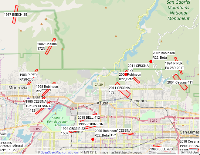
It turns out that most (all?) such incidents are investigated by the NTSB. And they then write a report. And then somebody puts all the reports into a database and makes them available on the internet. How helpful! For my purposes, I mostly care about the location each impact site. Some reports actually have a lat/lon pair, while others have a range/bearing from some "observing" airport. Many reports don't have either, but there isn't a lot I can do about that.
In any case, I did some typing, and produced the map linked above:
http://ntsb.secretsauce.net/map/
This shows all the incidents after 1982 that have a location listed in an NTSB report. The locations are represented by a red circle (if a report lists a latitude/longitude) and/or a range/bearing area (if a report lists a weather observation and its relative location to the crash site). Clicking an object produces links to the different versions of the NTSB reports. The data isn't very accurate it looks like (sometimes not even close to right), but the text of the reports often has more specific information. I have all the data in the US, and you can use the interactive map in the above link to look at any of it.
The code, docs, and full final dataset appear here.
And I learned of exciting things looking at this. For instance in 2016 a Boeing 777 cleared Mt. Wilson by 1000 ft, not counting the towers. And this happened.
Huge thanks to Erik Price and Chris McKenzie for help in getting the interactive map working.